Saturday, May 23, 2009

May 19, 20 - a visit to London,


We left Newquay, the surfing capital of the UK, to visit London. The walking part of our trip was complete, and although we did not walk the entire path, we had a fantastic variety of terrain.
Spending 5 hours on a train, Newquay to Par, then Par to London, we got to our hotel around 4:30PM. We spent a full day, May 20, visiting popular spots in London: the palace guard color practice, Churchill's Cabinet War Rooms, the London Eye, and the Imperial War Museum.
Reflecting on our trip, we saw a rugged coastline, bright-wet-dry-windy-calm weather, and towns and villages from tiny to gigantic. It was not a relaxing vacation, but that's the way we like it, we can rest on the flight home.


Monday, May 18, 2009

May 18 - Treyarnon Bay to Newquay


Today was the last day of our walk down the Cornwall coast, and we would be sadder if the wind had not been so blustery and the sun so hidden, today was no exception. Our schedule was booked weeks in advance, so we had to keep our schedule. The weather uncertainty is part of the fun, and we took it in stride. This trip had the weather of the stormiest days in the bay area during January or February.
The flowers were abundant along these 100+ miles, and many of these flowers grow low so as to tolerate the wind.

In this photo, sea foam has been blown up from 50 ft below, did I mention it was windy.

The day was long, about 13 miles of walking up and down the contours of the coast and our feet are sore. We had a good adventure and really felt alive.

I updated the photo album here:

http://picasaweb.google.com/ferryman.nov5/CornwallCoastWalkingTripMay2009?feat=directlink

Tomorow, we catch a train to London for a full day of the city, a welcome change.

Sunday, May 17, 2009

May 17 - Padstow to Treyarnon Bay

..
.
.
.
.
.
.
.
.
.
.
.
.

WIND!
The wind was relentless today as we walked the circuitous path southwest of Padstow. The morning started out with rain and swirling wind, as we walked next to the doombar (a sandbar in the estuary). Then as we climbed out of the Padstow estuary area, the wind grew to terrific strength. We were walking like drunkards on the hill tops due to the gusts, not a place we wanted to linger despite the great views. There were a few spots where the wind gusts and our nearness to the cliffs was a worry.... but we walked on.
We had to keep our jacket hoods tight in order to keep the hats on our heads. At one moment, a wind gust took my hat off the edge, but only down 20 ft. or so. I managed to climb down and get it on the steep slope, it's a lucky hat.
We saw many surfers at Harlyn Bay... surfing in the UK? Must use extra thick wetsuits.
You've got to be an optimist to live here.
We walked about 10 miles today, tomorrow is the longest day of our walk, and sadly, our last one.

Saturday, May 16, 2009

May 16 - Port Isaac to Padstow


We had a strong headwind as we walked the 10-12 miles down the coast to Padstow. The sun was out but there were fast moving clouds blowing towards us, later we had a couple of quick rain showers. Huge waves were crashing along the rocky coast making for dramatic views. We finally found a sheltered place from the wind and had a quick lunch.
After a blowing sand, stinging-your-face walk on the last path section, we caught the small passenger ferry to Padstow across the estuary (avoiding another 20 miles of walking). We had a small hail storm as we walked up to the grocery store for our provisions, it passed quickly and we saw the rainbow as a reward.
Having a great time, but we are nearing the end of our trip.


May 14 and 15 - Port Isaac

.
.
.
.
.
.
.
.
.
.
.
.
.
We have been without internet access for a couple of days now, living rough (not really).

After Tintagel, our next stop was the very small coast village of Port Isaac. We arrived on Thursday May 14, and also stayed there May 15 doing a little site seeing and looking for where they were filming the latest series of Doc Martin. Sure enough, we found the film crew had posted a schedule and we found them in the nearby Port Gaverne.

We stayed at the Slipway Hotel, with a view smack dab in the front center of the town, where the lifeboat station is located. It's a busy area, with tourists in cars trying to get through the narrow streets. They allow parking on the beach, but people must be out before the large tide comes in.

These days were marked by very windy conditions and on again - off again rain. Plus, this is cold weather by California standards... the locals had shorts and sandals on, we had our gore-tex hoods up. The air is very fresh coming right off the ocean.


Thursday, May 14, 2009

May 13 - Crackington Haven to Tintagel


Today was a day with a lot of exposed up and down walking on rough trails and steps. We saw some dramatic coastal cliffs, canyons, inlets, and waterfalls during the day with 2500 to 3000 feet of climbing and descending. 11 miles of walking, and we were tired.
Tintagel is supposed to be the birthplace of King Arthur. There are the remains of a 1000 year old castle, which we plan to see, time permitting. We also got a good look at Merlin's cave. The castle is on an island of rock a few hundred feet above the Atlantic. A good defensible location for a castle.

Tuesday, May 12, 2009

May 12 - Bude to Crackington Haven


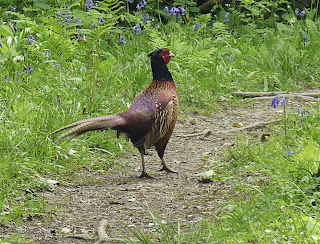
We had some company on the path today...


At last we got in a good day of walking; about 10 miles with many ups and downs.
The weather was windy and cool to warm depending on the micro climate we were in.
Deciding on a more varied route, we walked off the path at Millook, going up the wooded valley.
This less travelled route brought us by a couple of medieval settlements, now farms, then back to the coast path.

For a good description of this day's journey, refer to E's blog here:
http://ukwalkingtripmay09eb.blogspot.com/

These days are full: lots of walking, washing clothes, looking for food, exploring around, etc...
I'll post more photos when I get the time.
Tomorrow, we go to the castle where King Arthur was the, well the King or at least born... (or so they say).

Monday, May 11, 2009

From the rugged North Devon Coast to the Cornwall Coast


Today is our first day in a couple where we can get the intenet, we are now in Bude, Cornwall. Here is a view looking down the coast path a few miles from Bude.

We walked 8 miles today from the Bush Inn, Morwenstow. The weather was very clear, but it was quite windy. The next couple of days will probably rain, but no worries.

I think the food is a bit expensive here for being so far out in the countryside. But, it's very tasty since it comes from many locally grown ingredients. There is very little fruit to be found, I'm sorry to say.

My legs seem to be fine now after a few days of walking and what seems to be an unreasonable amount of time spent trying to stretch and massage the muscles and joints.

Friday, May 8, 2009

link to photo gallery:
http://picasaweb.google.com/ferryman.nov5/CornwallCoastWalkingTripMay2009?feat=directlink
Update: Friday, May 8....
Yesterday, we could not get internet access, so I'll update the story since Barnstaple.

Thursday, May 7
We walked around Barnstaple, saw the church, castle mount, museum and shops until it was time for our afternoon bus to Westward Ho!, a 40 minute ride.
Westward Ho! was named after a book, it is located right on a long beach, where the tide goes in and out 1/3 of a mile or more.
At low tide, relics of human life from 10,000 years ago can be seen.

Misty drizzle started when we arrived in the small town.
We stayed at the Culloden House high on the hill with a wide view of the coast.
Built in 1865, it's now a B&B.
Had a tasty dinner at The Potwallopers restaurant.

Friday, May 8
A very windy and chilly day.
My legs starting hurting quickly walking down into town to buy our lunches.
Made it 1.5 miles before the legs hurt too much... impossible to predict, a real bummer.
The legs were the problem, not the stiff headwind or rain squalls, we decided to find a plan B.
We walked inland for a couple of miles and found small town and a bus stop.
The bus arrived and hour and a half later, in the mean time, we ate lunch in the church yard.

We are staying in Clovelly tonight, in an old hotel down on the water.
A private town, with houses at least 500 years old, very quaint and steep down to the ocean.
Tomorrow, we need a plan A and a plan B, depending on how my legs do.

Thursday, May 7, 2009

photos from Barnstaple

walk under the road bridge

direction arrows

museum fence

flowers
Posted by Picasa

a few photos


Posted by Picasa

We had our day of travel, taxi, air, train, walk, and now we are in Barnstaple.

Tuesday, May 5, 2009

Eileen and I decided to each have our own blog to express different viewpoints of the trip.
Here is Eileen's blog url:

Today is Tuesday, 5/5, we fly out this afternoon bound for London. Then we take 3 trains to get to Barnstaple, Devon....

Thursday, March 26, 2009

planning ahead for our walking trip


We start in Barnstaple, Devon, and end up in Newquay, Cornwall walking along the Southwest Coast National Trail, a walking distance of over 100 miles. Each night we stay in either a B&B or a small hotel near the trail.
... we'll be looking for the production crew of the Doc Martin British TV series filming somewhere along the Cornwall Coast, and enjoying the tiny hamlets and open spaces that we find along the way....

The photo shown here is from a previous walking trip on the Cotswold Way. Many shady path sections like this are covered with wild garlic, which was first brought to Britain by the Romans more than 2000 years ago.